Relocating the mapmapmaker

Huge changes are afoot in Lucianoland.

After almost 11 years as a resident in Korea, including a productive career teaching and an intense battle with cancer that nearly finished me, but which my excellent doctors here helped me to overcome, I am forced by circumstances beyond my control to move back to the US.

I am thus currently very busy (overwhelmed) with the preparations for the move. Once back in the US – within a month – I have no idea what my job prospects will be or even what sort of work I will do.

I may be too busy to map or participate in OGF much. Then again, I may actually participate in OGF more, as I seek a way to deal with stress and just to relax doing something familiar and comforting in my down time. I can’t predict.

Anyway, if I don’t respond for long periods, you know what’s happening.

Many Lines

I have drawn many, many lines.

The contour work for Makaska is coming along. I made the decision to complete ALL the contours before placing infrastructure, and so far except for one little experiment at the southwestern border (which was meant mostly to give some hints to my southern neighbor since he’s building a metropolis right across the frontier), I have stuck to my plan.

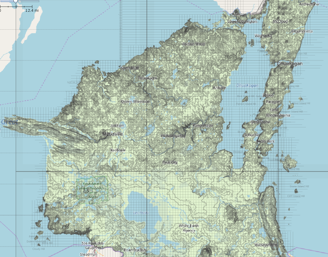
Overall, I feel happy with my progress. Below is a current screenshot in JOSM. The contour work is divided into 6 separate “degree square” files (you can see the “edges” of each layer file) but I can load them all into JOSM to view my progress, although for actual work I’ll close all of them except the one where I’m working. I also have the “pseudo-PLSS” layer loaded, which is a grid of mile-square “sections” based on the fictional 1841 survey. I think it’s looking pretty good.

picture

I could probably load it right now, except for the band  across the middle, including Freeborn, Battle Plain, Lac Perdu, and Taylor Parishes.

Music to map by: Silvio Rodríguez, “La gaviota.”

Field work for mapping Ohunkagan

I haven’t mapped anything, these last two weeks. But I thought about mapping a lot. That’s because I spent the last two weeks in Seattle and Portland for a family emergency, driving around and thus getting lots of ideas and thoughts for Makaska. Certainly I had already been intending the main metropolis, Ohunkagan, to have some similarities with Seattle (although with a Minnesota climate), situated as it is on an isthmus, but getting to drive around there and around Portland, too, gave me some more ideas, anyway. Call it a kind of “Field research” for eventual mapping.

This is a pretty short entry, then, just to give an update of what I’m up to on the geofiction front.

Now that I’m back in Korea, I may have some more time and opportunity to do more mapping.

Music to map by: Taylor Swift, “Delicate.”

Lakes

I have been working quite a bit on my fictional “US” state, Makaska. But for the most part I am focused on physical geography: refinining the contour files (a continuous work-in-progress), and thinking about the hydrology (rivers and lakes) and landcover (grasslands and woods).

I did set up 2nd order political divisions (counties) which I have decided to call parishes. And I set up a moribund rural township system which will drive things like road layout, farms, etc., when the time comes, and which is intended to replicate the old US PLSS system (see also my previous blog post here). The townships will also be the basis for my landcover relations – a six mile square seems about the right level of scale for a specific landcover relation, not so big as to be unmanageable once a high level of detail is introduced, but not to local so as to be difficult to develop systematically.

I’m pretty happy with the map already. There are so many lakes! And I’m just getting started. Minnesota allegedly has 10,000 lakes – in fact, it’s quite a lot more than that, from what I’ve heard, but that’s the round number used when marketing the state, and if you impose a cut-off at lakes around the size of 5 acres, 10,000 is pretty close.

I suppose I could shoot for a pro-rated number of lakes for the much smaller Makaska. If Minnesota has 10,000 at 86,936 sq mi, that’s 0.11 lakes/sq mi. So if Makaska has 6875 sq mi, then it should have 756 lakes of 5 acres or more. I may be getting close to that already.

Music to map by:  Control Machete, “Andamos Armados.”