Relocation: Phase 2 Complete – Moving to Mahhal

I have moved to Mahhal. Well. The closest real-world place that I know of, and the basis of my Mahhalian concept to some degree: southeast Alaska.

I have relatives here. I didn’t grow up here, but it’s easy for me to think of it as home, and I am now intending to settle here. This is partly because of the demands of family, but also because the Korean project (my living there) was becoming unsustainable, for me personally.

I will hopefully have more time to do some mapping – in Mahhal, Makaska, and Ardisphere.

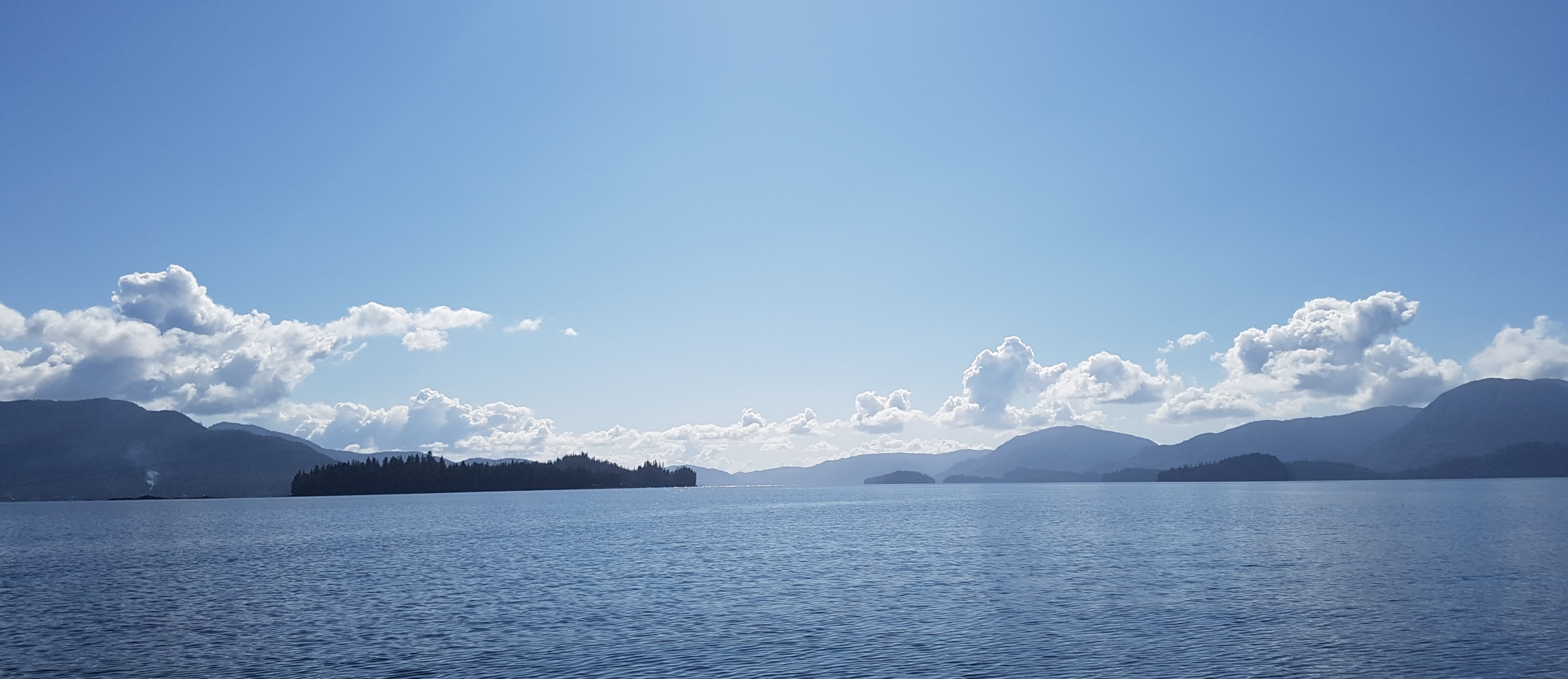
Out on my uncle’s boat, this morning:

picture

Music to map by: 유승준, “사랑해 누나.”

Relocation: Phase 1 Complete

I have successfully moved out of my home in northwest Seoul. I’m in a temporary situation in Portland, Oregon. I will now be putting the pieces in place to get settled in Southeast Alaska. Moving to Alaska is complicated, and now I need to get my stuff there. I shipped my possessions in Korea directly there, but now I have stuff in the lower 48 that needs to be moved north.

I lived there before once – I have relatives there.

Music to map by: Wado, “Esqueleto.”

Relocating the mapmapmaker

Huge changes are afoot in Lucianoland.

After almost 11 years as a resident in Korea, including a productive career teaching and an intense battle with cancer that nearly finished me, but which my excellent doctors here helped me to overcome, I am forced by circumstances beyond my control to move back to the US.

I am thus currently very busy (overwhelmed) with the preparations for the move. Once back in the US – within a month – I have no idea what my job prospects will be or even what sort of work I will do.

I may be too busy to map or participate in OGF much. Then again, I may actually participate in OGF more, as I seek a way to deal with stress and just to relax doing something familiar and comforting in my down time. I can’t predict.

Anyway, if I don’t respond for long periods, you know what’s happening.

Many Lines

I have drawn many, many lines.

The contour work for Makaska is coming along. I made the decision to complete ALL the contours before placing infrastructure, and so far except for one little experiment at the southwestern border (which was meant mostly to give some hints to my southern neighbor since he’s building a metropolis right across the frontier), I have stuck to my plan.

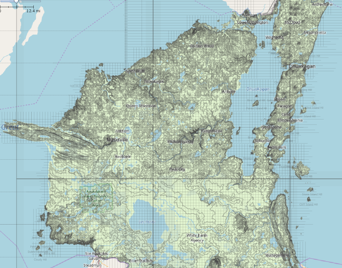
Overall, I feel happy with my progress. Below is a current screenshot in JOSM. The contour work is divided into 6 separate “degree square” files (you can see the “edges” of each layer file) but I can load them all into JOSM to view my progress, although for actual work I’ll close all of them except the one where I’m working. I also have the “pseudo-PLSS” layer loaded, which is a grid of mile-square “sections” based on the fictional 1841 survey. I think it’s looking pretty good.

picture

I could probably load it right now, except for the band  across the middle, including Freeborn, Battle Plain, Lac Perdu, and Taylor Parishes.

Music to map by: Silvio Rodríguez, “La gaviota.”

Field work for mapping Ohunkagan

I haven’t mapped anything, these last two weeks. But I thought about mapping a lot. That’s because I spent the last two weeks in Seattle and Portland for a family emergency, driving around and thus getting lots of ideas and thoughts for Makaska. Certainly I had already been intending the main metropolis, Ohunkagan, to have some similarities with Seattle (although with a Minnesota climate), situated as it is on an isthmus, but getting to drive around there and around Portland, too, gave me some more ideas, anyway. Call it a kind of “Field research” for eventual mapping.

This is a pretty short entry, then, just to give an update of what I’m up to on the geofiction front.

Now that I’m back in Korea, I may have some more time and opportunity to do more mapping.

Music to map by: Taylor Swift, “Delicate.”

Lakes

I have been working quite a bit on my fictional “US” state, Makaska. But for the most part I am focused on physical geography: refinining the contour files (a continuous work-in-progress), and thinking about the hydrology (rivers and lakes) and landcover (grasslands and woods).

I did set up 2nd order political divisions (counties) which I have decided to call parishes. And I set up a moribund rural township system which will drive things like road layout, farms, etc., when the time comes, and which is intended to replicate the old US PLSS system (see also my previous blog post here). The townships will also be the basis for my landcover relations – a six mile square seems about the right level of scale for a specific landcover relation, not so big as to be unmanageable once a high level of detail is introduced, but not to local so as to be difficult to develop systematically.

I’m pretty happy with the map already. There are so many lakes! And I’m just getting started. Minnesota allegedly has 10,000 lakes – in fact, it’s quite a lot more than that, from what I’ve heard, but that’s the round number used when marketing the state, and if you impose a cut-off at lakes around the size of 5 acres, 10,000 is pretty close.

I suppose I could shoot for a pro-rated number of lakes for the much smaller Makaska. If Minnesota has 10,000 at 86,936 sq mi, that’s 0.11 lakes/sq mi. So if Makaska has 6875 sq mi, then it should have 756 lakes of 5 acres or more. I may be getting close to that already.

Music to map by:  Control Machete, “Andamos Armados.”

1320 feet

I continue to be really busy with work, so I don’t have a lot of time for mapping or server stuff.

I have been progressing further on Makaska. The hydrology is pleasing, and contours feel like they’re falling into place and that it will be possible to actually finish them in a finite amount of time.

Another thing that needs working on to make a truly “US analogue” midwestern state such as Makaska, is that there need to be realistic county and township divisions. This means replicating the kinds of the errors and styles of 19th century “compass and chain” survey methods.

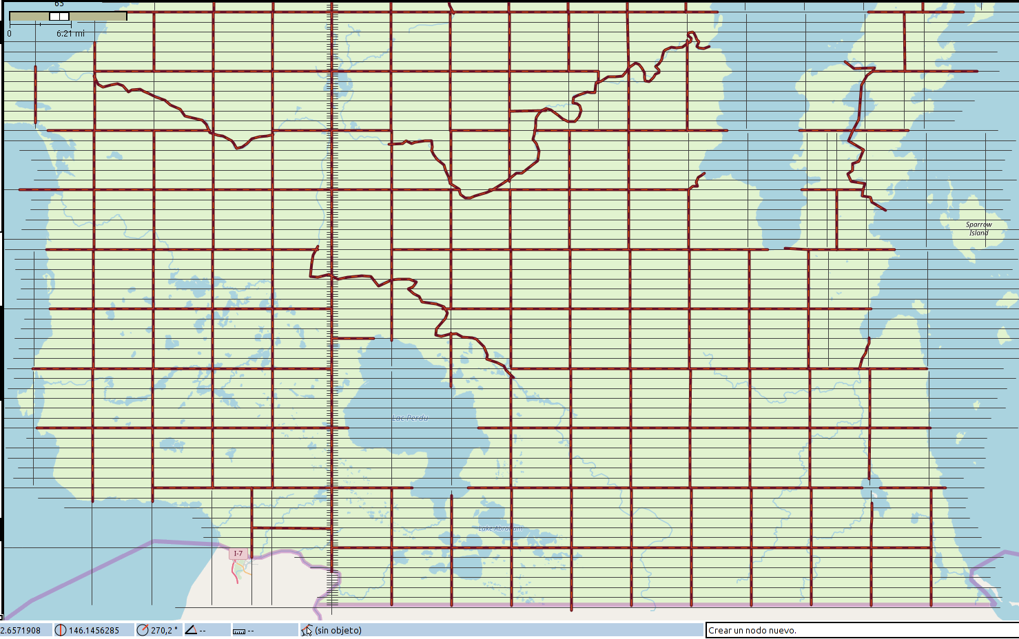
I am quite pleased with my results – not yet uploaded because I want to make sure the townships I’ve laid out are in sync with my ideas about where the rivers and county lines will go and I want everything to have a name, of course. Anyway, here is a screenshot in JOSM.

picture

My title refers to the fact that the 19th century North American grid style was based on the mile, which is 5280 feet. A standard township was made up of 36 “sections”, 6 miles by 6 miles square. Each “section” was divided into quarters (160 acres, 2640 feet to a side) and those were further divided into “quarter quarters” (40 acres, 1320 feet to side). So in recreating the survey process for my fictional place, I “paced” my way across my entire state in 1320 foot lengths, imagining my surveyors stretching out their chain over and over. By doing it this way, I could introduce random “mistakes” that would render the result realistic, and I could account for the way the curvature of the earth forces periodic resets of the alignments of the north-south meridian lines.

So my grid contains these inconsistencies, and in a few places, I have deliberately failed to “walk” perfectly north/south/east/west, forcing a later realignment.

In the picture above, the little “tic marks” on the north-south “base meridian” are 1320 feet apart.

Music to map by: 블락비, “닐리리 맘보.”

Makaska

Work has been quite rough, lately. So I haven’t done much of anything geofictional.

However, isleño recently took AR120 “live” in OGF. AR120 is meant to be a kind of OGF version of the US. And I had long planned to make a state in this country. I gave up the vast majority of my territory in Mahhal (returning it to the unused country pool as AN160e) and exchanged it for a smallish “Great Lakes” state. This state will be Makaska.

Makaska is roughly modeled on Minnesota, and other upper midwest locations (Wisconsin, Michigan, Dakotas). It has a large, isthmic metropolis, called Ohunkagan – this is real-world Dakota language, which I studied once, long ago. Many of the place-names in Makaska will be from Dakota, including the actual state’s name.

I have actually done a lot of work on Makaska. But its shape was vague because I wasn’t sure which location I would get in OGF to implement it. So it was kind of schematic, with all these fragments of contour sections, hydrology, counties, etc.

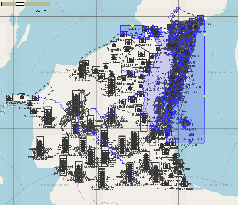
Now I’ve begun the work of adapting these schemata to its actual location. I have more than 10 different JOSM layers, and I go back and forth, adjusting a river, rearranging some towns, etc. I used JOSM’s opendata plugin to upload about 300 placenames directly from a spreadsheet where I’d been working on them. So that’s a start.

Here’s a screenshot of the work-in-progress.

picture

Music to map by: Niloo, “Ola Ola.”

A different sort of worldbuilding

This isn’t exactly geofiction, but I was messing around with a new project on my server.

Way back in the day (I am somewhat old), I used to play MUDs (Multi-User Dungeons). These are text-based computer games of various kinds – no graphics at all. They’re a kind interactive “choose your own adventure” text, you might say. But the game mechanics in them are the ancestors of modern MMORPGs such as World of Warcraft, and there are even conceptual connections to Grand Theft Auto or Minecraft.

MUDs are quite old – they existed on mainframes at businesses and universities before PCs were even a thing, starting in the 1960s. Because of my family’s connection to the local university, I was a rare child of the 1970s who actually played computer games before PCs were invented! These were MUDs and other text-based games.

When I noticed I had my own server up and running, it occured to me that I could build a MUD. Possibly, it’s not even that hard. Sure enough, there is open-source software that will run a MUD on a server for you.

I chose a package called CoffeeMud. I’m still messing with it. It’s very unlikely I’ll ever do anything with it. But I had this domain-name, “Hellbridge.com”, lying around, so I thought, sure, make a MUD.

  _    _        _  _  _            _      _              
 | |  | |      | || || |          (_)    | |             
 | |__| |  ___ | || || |__   _ __  _   __| |  __ _   ___ 
 |  __  | / _ \| || || '_ \ | '__|| | / _` | / _` | / _ \
 | |  | ||  __/| || || |_) || |   | || (_| || (_| ||  __/
 |_|  |_| \___||_||_||_.__/ |_|   |_| \__,_| \__, | \___|
                                              __/ |      
            Hellbridge.com                   |___/       
            Powered by CoffeeMud v5.9

I originally acquired the “Hellbridge.com” domain for a quite different purpose: It was intended to be a “satire-website” for a place where I once worked, which had a name where “Hellbridge” was a similar sound but darker connotation. But looking at it now, I thought it would make a great name for a MUD. So there it is.

I liked the CoffeeMud package because the admin and config of the site is mostly done from within the game. That’s cool. So I create an “Archon” character, who is like God. I walk around the MUD and type “Create chair” and a chair falls from the sky. Likewise with any other object, room, monster, or character class. That’s fun.

The Archon character is created in the empty, default “Fresh Install” room, by reading a book that is placed there. I read the book and I became a God.

Nice book. Note the stats jump in the prompt.

<20Hp 100m 100mv> read book
The manual glows softly, enveloping you in its magical energy.
The book vanishes out of your hands.

<1403Hp 571m 595mv>

It’s not live yet. It may never be. But meanwhile, I thought it was interesting to try it out.

It’s a little bit like geofiction – you’re creating an imaginary world, after all.

Music to MUD by: Maná, “En el muelle de San Blás.”
Mahhal Contours

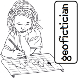
I’ve been trying to organize my contour work for the new, smaller Mahhal. I’ve scaled the country back to a size where I think I can actually accomplish contours for the whole place in a finite amount of time, using my current methods. Mahhal is now just the northwesternmost 15% of the original archipelago. The remaining islands will eventually serve some other purpose, I suppose. Hopefully, it will be something very low density (Antarctic tundra and glaciers!).

Just like the Ardisphere, I felt the need to divide the contour work into manageable-sized “chunks”. Since the contour conversion program is based on a division of the planet into “degree squares” (which aren’t exactly square except at the equator, but anyway), I decided to do the same as I’d done in that country. However, because of the much higher latitude, and the fact that they’re all islands, I didn’t opt to try to subdivide each degree square into “bands.”

Currently I have four squares that are active. The 84°E Line splits Tárrases, so I have the two squares that straddle that island. And I have the two to the north, which are the northernmost reaches of the archipelago.

Below is a screenshot of the work, in JOSM. Each square is a different file (layer), so JOSM has four files open. Tárrases is complete, of course. The island directly west of the Duchy, Tteu (ዕሓ ጼዐ), is complete (though I might adjust some of it, later). Now the big island northeast, Kkogyra (ዕሓ ቆግራ) is complete too. That is where the capital and largest city of the Jessitim Kingdom, Piropeta, will be.

picture

The matching view on the OGF standard map is here.

Music to map by: Rural Alberta Advantage, “On The Rocks.”